Property Histories
At their choice, owners may record the ownership and development history of individual parcels on Lake Julia.
At their choice, owners may record the ownership and development history of individual parcels on Lake Julia.
This page is incomplete and will be filled in gradually as owners contribute their property histories. Check back as more stories are added over time.
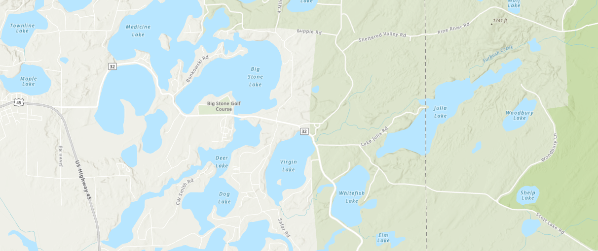
Any owner may add their property's history to this section. Contact the site administrator to contribute. House numbers correspond to the lake map.
Jump to...
Houses #1–10
| House # | Built | Description | Ownership History | Current Owner |
|---|---|---|---|---|
| #1 | — | No content available | — | — |
| #2 | — | No content available | — | — |
| #3 | — | No content available | — | — |
| #4 | — | No content available | — | — |
| #5 | — | No content available | — | — |
| #6 | — | No content available | — | — |
| #7 | — | No content available | — | — |
| #8 | — | No content available | — | — |
| #9 | — | No content available | — | — |
| #10 | — | No content available | — | — |
Houses #11–16
| House # | Built | Description | Ownership History | Current Owner |
|---|---|---|---|---|
| #11 | — | No content available | — | — |
| #12 | — | No content available | — | — |
| #13 | — | No content available | — | — |
| #14 | — | No content available | — | — |
| #15 | — | No content available | — | — |
| #16 | — | No content available | — | — |
Houses #17–20
| House # | Built | Description | Ownership History | Current Owner |
|---|---|---|---|---|
| #17 | — | No content available | — | — |
| #18 | — | No content available | — | — |
| #19 | — | No content available | — | — |
| #20 | — | No content available | — | — |
Houses #21–24
Houses #21–24 occupy land originally acquired by the Thunder Lake Lumber Company on December 20, 1859 from Wisconsin state holdings. The area borders the Read property (#20) northward, Government Point (Piper's Point, #25) southward, Lake Julia westward, and Nicolet National Forest eastward.
Irv and Dora Koten purchased this property during the 1940s. Their son Don constructed the first structure, "Koten Point" (#21), in 1953. The Kotens subsequently divided southern portions among other families.
Harmony Lane is privately maintained by the owners of properties #21–24. The unpaved road spans approximately 1.3 miles from its Bradford Lane entrance to the Mayer property, with the Munkwitz and Schlueter properties at midpoint.
The road's former name was "Ups-N-Downs" until approximately 1995, when Forest County assigned the official designation "Harmony Lane" for emergency services. Local children initially removed the new sign; it was reinstalled in reinforced concrete.
| House # | Built | Description | Ownership History | Current Owner |
|---|---|---|---|---|
| #21 | 1953 | Built by Don Koten — the first structure on the Harmony Lane parcel. Known as "Koten Point." | Koten family (~1940s)↳ (2005) Rick & Paula Mayer | Mayer, Rick & Paula |
| #22 | 1957 | Built on land from the Koten family. Passed through the Augustine and Munkwitz families. | Koten family↳ (1956) Leland Augustine↳ (1957) Adam Letsch↳ (1958) Doris & George Munkwitz Sr.↳ (2003) Charles & George Munkwitz | Munkwitz, George |
| #23 | 1956 | Built on Koten land. Leland Augustine was the maternal grandfather of Pete Schlueter, current co-owner. | Koten family↳ (1956) Leland Augustine↳ (1980) Marion Schlueter-Davis & Betty Gibson↳ (2003) Charles (Pete) & Julie Schlueter | Schlueter, Pete & Julie |
| #24 | 1957 | Built on Koten land. Passed through several owners before the Munkwitz family acquired it in 1963. | Koten family↳ (1956) Leland Augustine↳ (1957) Jim Steibel↳ (1960) John Allen↳ (1963) Chuck & George Munkwitz | Munkwitz, Chuck & Susan |
Houses #25–34
Houses #28–33 are located on land originally acquired by Harry Gray Smith around 1916. Harry sold sites #28–30 to his brother Ernest Bradford (née Smith) in 1927. When Harry died in 1949, his remaining land — including the Smith cabin (#33) — descended to Bradford to repay Depression-era debt. Bradford later sold sites #31–33 to Wallace and Ada Evans of Davenport, Iowa.
Houses #25–27 at the northern end of the lane have more limited documented history at this time.
| House # | Built | Description | Ownership History | Current Owner |
|---|---|---|---|---|
| #25 | unknown | Known as "Government Point." Further details not yet documented. | Piper family | Piper |
| #26 | unknown | Further details not yet documented. | Reckmeyer family | Reckmeyer |
| #27 | unknown | Further details not yet documented. | Reckmeyer family | Reckmeyer |
| #28 | unknown | Originally Bradford land. Passed through the Eppler and McPherson families before current ownership. | Bradford land↳ Eppler↳ McPherson↳ Jakubowski | Jakubowski |
| #29 | unknown | Originally Bradford land. Passed through the Showers and Stratton families before current ownership. | Bradford land↳ Showers↳ Stratton↳ Wahlstrom | Wahlstrom |
| #30 | 1927 | Site of the original "Little Cabin." Bradford land sold to the Mott family, then to Nathan and Marion Wauda. | Bradford land↳ Mott family↳ Nathan & Marion Wauda↳ Spicer↳ Holz | Holz |
| #31 | unknown | Bradford land sold to Wallace and Ada Evans. Their daughter Yvonne and her husband built the house; it later passed to the Lerner family. | Bradford land↳ Wallace & Ada Evans↳ Yvonne Evans & husband↳ Lerner | Lerner |
| #32 | unknown | Bradford land sold to Wallace and Ada Evans, who built an A-frame structure. Inherited by David Evans. | Bradford land↳ Wallace & Ada Evans (built A-frame)↳ David Evans (inherited) | Evans, David |
| #33 | ~1916 | The original Smith family cabin. Descended to Ernest Bradford in 1949 to repay Depression-era debt. | Harry Gray Smith (~1916)↳ Ernest Bradford (1949)↳ Wallace Evans↳ Tomas Evans | Evans, Tomas |
| #34 | ~1998 | Originally a timber marshaling area and the site of Ernest Bradford's "Little Cabin." Hal Zager sold to John Snell, who constructed the present house. | Hal Zager↳ John Snell (~1998, built present house) | Snell |
Houses #36–45
| House # | Built | Description | Ownership History | Current Owner |
|---|---|---|---|---|
| #36 | — | No content available | — | — |
| #37 | — | No content available | — | — |
| #38 | — | No content available | — | — |
| #39 | — | No content available | — | — |
| #40 | — | No content available | — | — |
| #41 | — | No content available | — | — |
| #42 | — | No content available | — | — |
| #43 | — | No content available | — | — |
| #44 | — | No content available | — | — |
| #45 | — | No content available | — | — |
Houses #46–49
| House # | Built | Description | Ownership History | Current Owner |
|---|---|---|---|---|
| #46 | — | No content available | — | — |
| #47 | — | No content available | — | — |
| #48 | — | No content available | — | — |
| #49 | — | No content available | — | — |